The aquifer of the alluvial terraces of the Béni Abbès palm grove is subject to a hyperarid climate. The groundwater salinity problem is caused by several human and natural factors, causing serious irrigation problems. Hydrochemical analyses over a 40-year interval show an alarming Spatio-temporal evolution of salinity: the drying up of the Saoura valley due, on the one hand, to the impact of the construction of the Djorf Torba dam, on the other hand to the strong evaporation which reigns, have seriously affected the quality of the waters of the infero-flow. In addition to the diffusion of salinity through the natural drain, the overexploitation of water from the terraces of the Saoura valley and the anarchic proliferation of wells in search of fresh water, intended for the irrigation of the palm grove, lead to a spectacular acceleration of this destructive phenomenon of the entire hydrogeological system of this region. In this work, old and new analysis results are used to make a comparison on the evolution of the aquifer. Such a comparative analysis has the advantage of making it possible to assess certain influences subject to severe natural and anthropogenic constraints on the acquisition of the chemical characteristics of water.
INTRODUCTION
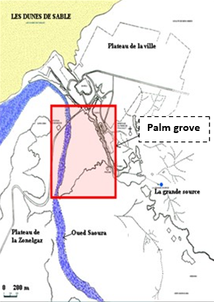
Groundwater aquifers in arid or hyperarid zones have classic hydrogeological and hydrogeochemical characteristics, their recharge and exploitation conditions induce particular problems that must be taken into account during their characterization. The Béni Abbès palm grove extends on the left bank of the Saoura valley, 6 km long and 5 km wide on average covering an area of 40 hectares. It draws water from the large spring, the foggaras and the wells dug in the alluvial and lower-flow terraces of the Saoura wadi. However, we note that the phenomenon of groundwater salinity is becoming more and more threatening. Indeed the problem caused by several human and natural factors generates serious problems with irrigation. This palm grove has lost 60% of its area and about three tiaras of its palm trees. The “Bayoudh” disease, socio-economic transformations, and sometimes mediocre decisions have contributed to this deterioration of the palm grove. This region has known for about thirty years an important economic boom with great development, especially in agriculture associated with a strong demographic expansion. Consequently, the groundwater in the region is increasingly sought by the inhabitants of the Oases where there is a deterioration in the quality of the water in the irrigated perimeters with the presence of high salinity which poses the problem of its use as drinking water and irrigation.
Our objective is to contribute to understanding the process and origin of groundwater salinization in these areas based on the spatiotemporal evolution of major and minor chemical elements.
Geographic location
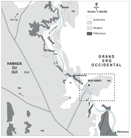
The oasis of Béni Abbès appears as the capital of the Oasis of the Saoura. It is located about 240 km south-west of Bechar and 880 km south-west of Algiers (Figure 1). The Saoura valley resulting from the junction of the Guir and Zouzfana wadis, represents the main watercourse of the North Western Sahara of Algeria. It is bordered to the east by the Grand Erg Occidental, and to the west by the Hamada du Guir and the Petite Hamada. At the level of the lower Saoura, it touches the mountains of Ougarta (Conrad & Roche, 1965; Oghenemaro et al., 2022).
The alluvial aquifer of the palm grove extends over an area of about 40 ha. The arid climate of the region is characterized by an average annual rainfall of between 30 and 40 mm (Scholler, 1945). The summer is hot and dry, and the winter cold and dry. Annual evaporation is high (around 2012 mm/year).
|
|
|
|
a) |
b) |
|
Figure 1. carte de localisation de Béni Abbès and the situation of the Béni Abbès palm grove (Roche, 1973, Modified). |
|
Hydrogeological characterization of the palm grove aquifer
Condition of deposit and supply
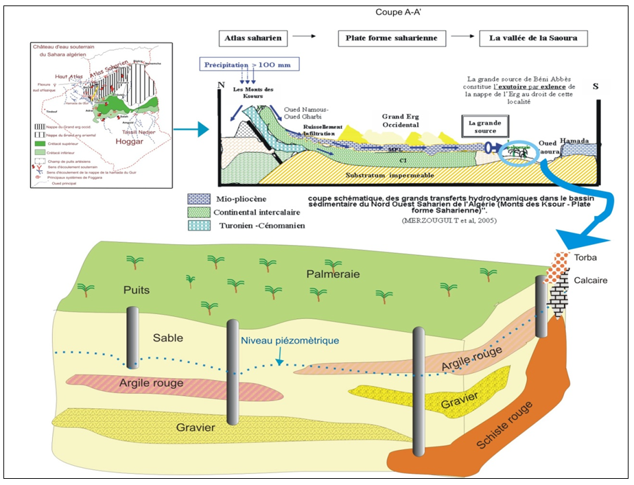
The aquifer system features two lithological units: the limestones and sandy marls of the Mio-Pliocene and the Quaternary formations. The reservoir is made up of Quaternary deposits made up of three layers (sand, clay, sand, conglomerate) with an average thickness of fifteen meters, the whole resting on a folded Upper Devonian schistose bedrock (Figure 2). The average thickness of the alluvial aquifer varies between 10 to 30 m (Tezangi, 2016).
The recharge of the alluvial aquifer of the palm grove is ensured by the infiltration of water from the large spring (flow 28l/s); by the lateral supply of water from the erg aquifer of a natural drain (Roche, 1973) and occasionally by floods from the Saoura wadi.
|
|
|
Figure 2. Condition and deposit of alluvial aquifers in the palm grove (ANRH, 1995). |
Groundwater flow and exploitation
The main palm grove is irrigated by the waters of the large spring and the extraction of wells dug in the alluvial aquifer. The continuously discharged flow is close to 8 l/s (2008 gauge), presenting 1/3 of the quantity discharged during the 1960s, i.e. 0.22 l/s/ha or an irrigated water height of 683, 35mm/year (GTZ Algerian-German., 2006).
The springs and foggara draining the water in the Neogene slope provide a total flow of less than 3 m3/h the other flow which passes through the lower strata of the Mio-Pliocene then in the Quaternary terraces (80l/s), gives a total flow of 83 l/s (Chavaillon, 1964; Glamazdin et al., 2022).
The aquifer system is exploited by 40 wells, most of which are equipped with pumps and motorized pumps. Withdrawals are evaluated at 52 l/s and the water table drainage rate towards the wadi is evaluated at 20 l/s. Also, a quantity of 20 l/s which evaporates, with a deficit of the order of 12 l/s reflects the intense overexploitation of the annual regulating reserve, which is marked by the continuous drop in the piezometric level and the intrusion of the salt wedge along the Saoura wadi (infero-flow).
The transmissivity of the Quaternary formations (Fabre, 1975), calculated on two piezometers, one located 200 m north of the ksar and the other near the pool, is equal to 2 10-4 and 4.4 10-4 m²/s. The values of the storage coefficients at the palm grove level vary from 0.02 and 0.059 in the North, in the South the values range between 0.014, 0.038, and 0.0011.
Twenty-one wells well distributed throughout the palm grove were monitored in an attempt to monitor the underground flow from the erg to wadi I
Piezometric evolution of the palm grove water table
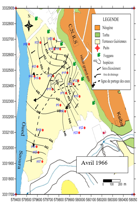
We first consider three piezometric situations: those of 1973, 1991, 2008, and 2009. The 1973 piezometric analysis (Roche, 1973) made it possible to identify the natural flow direction of the aquifer, which is from the North-East to the South-West in the direction of the Saoura wadi. The Saoura wadi drains the alluvial aquifer (Figure 3).
The 1991 piezometric analysis (Yousfi & Ait-Ahmed, 1992; Makhoahle & Gaseitsiwe, 2022) made it possible to record a new advance in the drawdown values of the palm grove water table. The worsening of the piezometric situation underlines a reduction of 1m linked to the construction of new wells, the deepening of existing wells, and the increase in pumped volumes following the electrification of pumps. This critical situation is mainly due to the continuous solicitation of the aquifer and the decrease in the share of the palm grove in the quantity of irrigation water from 2/3 to 1/3 (17L/s to 8L/s).
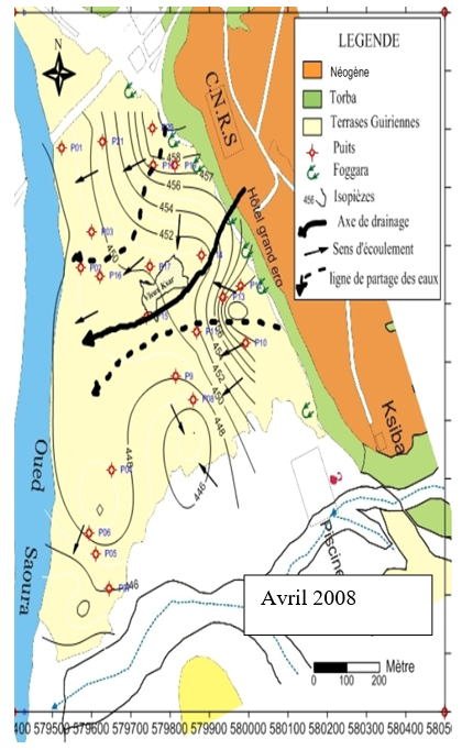
The piezometric state of 2008 and 2009 (Figure 4), indicates that near the Hamadian slope a drop in the piezometric level, accompanied by an alarming increase in salinity, it also shows that the depressions observed only increase with time. Indeed, the natural recharge (natural drain) does not manage to cover the extraction and the level of the water body of the lower flow of the surface of the palm grove. During our observation period in 2008 and 2009, the depth of the piezometric surface in the aquifer does not exceed 10 m (well 7), in most of the wells, it is in an average of 6 m. In 1973, the depth was often between 3 and 5 m, currently, it ranges between 2 and 9 m. Finally, the piezometric state of 2008 and 2009 marks the continuation of the evolution towards a lowering of the piezometric level and an increase in salinity, currently, the water table is almost stable.
|
|
|
Figure 3. Evolution of the water level of the palm grove. |
The annual measurement campaigns have made it possible to draw the curves of the evolution of the water level in the alluvial aquifer of the palm grove (Figure 4).
|
|
|
a) |
|
|
|
b) |
|
Figure 4. Piezometric map of the alluvial aquifer of the palm grove. |
Aquifer system and hydrogeochemical evolution
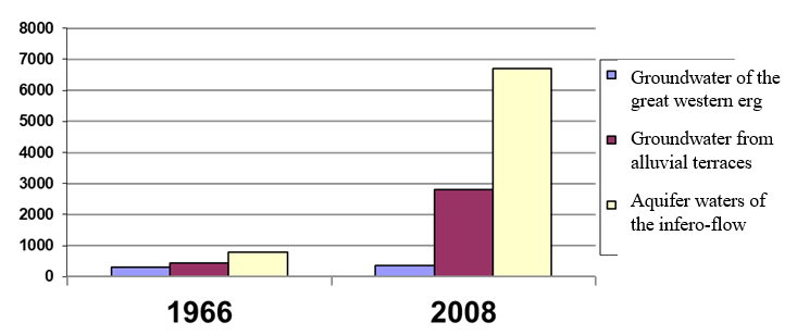
The Béni Abbès aquifer system includes more or less significant aquifers. To hydro-chemically characterize the water of each aquifer and to estimate their origin by correlating them with geology and piezometric. We proceeded to a compilation of data over an interval of 60 years, indeed several analyzes in our possession date back to the years 1963 and 2008 (Table 1). The series of hydro-chemical data collected is discontinuous, but it proves to be very useful in the study of the Spatio-temporal evolution of the physicochemical constituents, nevertheless it makes it possible to draw histograms and maps of the quantities of dissolved salts, as well as the exogenous migration of salinity. Concerning the aquifer of the terraces, the evolution is underlined from west to east. The values of cations and anions multiplied by 3 to 7 times at the level of Terrace 3, twice in terraces 2, and 1.5 times at the level of terraces 1.
The waters of the Grand Erg Occidental and the Hamada du Guir aquifer show a modest chemical evolution, they are characterized by a neutral pH and very low mineralization levels. On the other hand, according to their arrangement in relation to the axis of the Oued, the aquifers of the terraces and the inferno-flow, show an alarming evolution (Merzougui et al., 2008).
In 1966 (Figure 5); Only the lower flux shows a dry residue content of 5.1 g/l. At the level of the various terraces, this concentration does not exceed the value of 2 g/l.
In 2008 (Figure 5); the waters of the terraces and the inferno flow are more loaded with dry residue from 4 to 20 g/l.
Evolution of the salinity of the palm grove aquifer
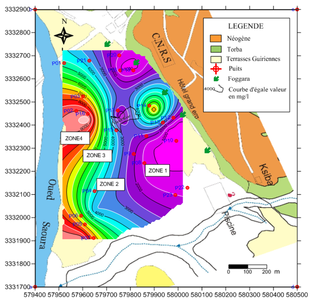
Roche described in his thesis that the waters of the area along the Saoura wadi have relatively low salt concentrations, not exceeding 2g/l, which is explained by the infiltration of water from irrigation of the large source with a large quantity and floods from the Saoura wadi in the alluvial aquifer of the palm grove. The waters of the upstream part of the aquifer show very low levels. On the other hand (Yousfi & Ait-Ahmed, 1992), found salinity values higher than 3 g/l. the drying up of the Saoura wadi, and the reduction in the share of the quantity of water intended for irrigation, are the main causes. The recharge of the alluvial aquifer has dropped. This high salinity can be explained by the geological nature of the alluvial filling, the anarchic evolution of the wells, and the increase in pumping have translated a call from the waters of the inferno-flow loaded with salt. With the 2008 map, three salinity zones can be identified, from the least concentrated (0.3 to 3g/l) in the center of the palm grove (3 to 7g/l) to the most concentrated (20 g/l) in the south -West (near the Saoura wadi) (ANRH, 2007).
In conclusion, the increase in salinity explains the high number of abandoned surface wells, excessive exploitation, generally exceeding the regulating power of the aquifer, leading to continuous degradation of water quality caused by anthropogenic and agronomic activities. . This increase in salinity essentially influences crop yield by destroying the soil structure. The low salinity on the edge of the Hamadian embankment is ensured thanks to the regular lateral recharge by the natural drain on the one hand, and by the artificial recharge of irrigation water from the large source of good quality on the other.
The results of the hydrochemical study on a profile confirm a slow underground flow; the average values make it possible to distinguish three types of behavior of the analyzed elements:
The first set of elements, including pH, EC, RS, HCO3-, Ca 2+, Mg+2, Na+, K+, and Cl-
The second set is characterized by very clear changes in salinity (Table 1).
Table 1. Hydrochemical characteristics of the different aquifers in Béni Abbès.
|
Water group |
Year |
pH |
Res. sec mg/l |
Ca++ mg/l |
Mg++ mg/l |
Na+ mg/l |
K+ mg/l |
Cl- mg/l |
SO4 mg/l |
HCO3 mg/l |
|
The groundwater of the great western erg |
1966 |
7.6 |
530 |
75 |
30 |
50 |
15 |
90 |
600 |
285 |
|
2008 |
7.7 |
556 |
96 |
27 |
40 |
10 |
80 |
850 |
310 |
|
|
2017 |
7,5 |
300 |
48 |
33 |
28 |
5 |
45 |
120 |
119 |
|
|
Groundwater from alluvial terraces 1 |
1963 |
7.5 |
625 |
110 |
40 |
90 |
12 |
85 |
900 |
400 |
|
2008 |
7.4 |
862 |
98 |
39 |
78 |
09 |
220 |
123 |
76 |
|
|
2017 |
7,19 |
960 |
138 |
56 |
97 |
10,5 |
165 |
220 |
308 |
|
|
Groundwater from alluvial terraces 2 |
1963 |
7.5 |
430 |
100 |
40 |
100 |
30 |
300 |
350 |
350 |
|
2008 |
7.7 |
3250 |
180 |
78 |
205 |
45 |
320 |
359 |
- |
|
|
2017 |
7,09 |
8050 |
473 |
632 |
2300 |
70 |
900 |
1500 |
305 |
|
|
Groundwater from alluvial terraces 3 |
1963 |
7.3 |
2000 |
120 |
45 |
280 |
50 |
210 |
290 |
300 |
|
2008 |
7.2 |
15000 |
400 |
1076 |
2500 |
230 |
8000 |
1630 |
400 |
|
|
2017 |
6,8 |
9245 |
516 |
659 |
1800 |
26 |
2850 |
3000 |
476 |
|
|
Aquifer waters of the inferno-flow |
1963 |
7.5 |
5802 |
148 |
52 |
95 |
15 |
180 |
220 |
400 |
|
2008 |
7.1 |
20587 |
1100 |
1076 |
3380 |
230 |
8400 |
2230 |
100 |
|
|
2017 |
7.2 |
15587 |
2100 |
1080 |
2380 |
300 |
7400 |
3230 |
440 |
Origin of the salinity of the alluvial aquifer of the palm grove
Salinity measurement campaigns at different horizons were carried out in zone 1, zone 2, and zone 3 as well as the lower flux (Figure 6).
Zone 1: good quality water, 1g/l to 2g/l salinity.
Zone 2: the salinity evolves from 2g/l to 5g/l, and contains water of average quality.
Zone 3: poor quality water. The salinity is high and evolves from 5g/l to 15g/l.
Zone 4 of (Infero-Flux): water of poor chemical quality. The salinity exceeds 15g/l.
The salinity is therefore greater at the bottom of the valley than upstream of the aquifer near the Hamadian slope, which confirms the intrusion of the salt bevel observed along the aquifer of the infero-flow at the edge from the wadi (Merzougui, 2011).
The interpretation of the chemical analysis by Piper's method further shows that most of the water samples from zone number one of the first terrace one and the infero-flow are sodium chloride, which is consistent with the hypothesis of the salinization of the aquifer by the advance of the infero-flow towards the three terraces.
|
|
|
Figure 5. Evolution of the dry residue of groundwater in the Beni Abbès region. |
|
|
|
Figure 6. zoning according to the salinity of the water in palm grove 2008. |
RESULTS AND DISCUSSION
The interpretation of the results of the piezometric and salinity study of the alluvial aquifer of the palm grove allows the following conclusions to be drawn:
The piezometric domes observed to the north and south of the ksar have increased over time under the effect of the recharge of irrigation water from the spring and the local bulging of the roof of the impermeable substratum;
CONCLUSION
The physicochemical study of the waters of the Béni Abbès palm grove shows that the waters are relatively mineralized when moving from the erg plateau towards the wadi due to intense evaporation on the one hand, and overexploitation of the groundwater on the other hand.
The waters of the Béni Abbés region are chlorinated with sodium and calcium, sometimes with calcium and magnesium bicarbonate. The predominance of chlorides (Cl-), sodium (Na+), and calcium (Ca++) are essentially due to the leaching of Mio-Pliocene limestones, and the presence of gypsum lenses and clays on the one hand and to processes chemicals resulting from evapotranspiration on the other hand.
Isotainer maps indicate an increase in salinity concentration from East to West, i.e. from erg to wadi according to groundwater flow, the series of hydrochemical data collected are discontinuous, but they prove to be very useful in the study of the Spatio-temporal evolution of the physicochemical constituents, they make it possible to draw histograms and maps of groundwater qualities, as well as then the exogenous migration of salinity. Indeed, this problem caused by several anthropogenic and natural factors generates serious irrigation problems. Hydrochemistry shows that the wells located on the edge of the large erg are not attacked by salinity. On the other hand, those located on the banks of the Saoura are very salty (15 to 20 g/l). In addition, the water taken from the wells of the palm grove generally has chloride-calcium and magnesium facies, sometimes calcium bicarbonate.
Water potability goes from excellent to poor potability depending on the position of the wells in relation to the Saoura wadi. The use of major and minor chemical elements has allowed us to understand the process of water salinization. Thus, this salinization would come from the dissolution-precipitation of the aquifer rock, evaporites, and base exchanges.
ACKNOWLEDGMENTS: None
CONFLICT OF INTEREST: None
FINANCIAL SUPPORT: None
ETHICS STATEMENT: None
ANRH. (1995). Hydrogeological map of the Bechar region Scale 1/500,000 (Explanatory note).
ANRH. (2007). Groundwater quality map in the wilaya of Bechar.
Bounar, R., Nouidjem, Y., & Arar, A. (2018). Ecology and floristic diversity of Takoucht Massif chain in Babors (Be-Jaia, Algeria). Entomology and Applied Science Letters, 5(2), 26-35.
Chavaillon, J. (1964). The Quaternary Formations of the North-Western Sahara (from Colomb-Béchar to Reggane). Geology and prehistory. Paris: Publ CNRS, Geol series; 393p.
Conrad, G., & Roche, M. A. (1965). Stratigraphic and hydrogeological study of the southern end of Hamada du Guir. Geological Society Newsletter, France, 7, 695-712.
Fabre, J. (1975). Introduction to the geology of the Algerian Sahara. Ed. SNED, Algiers, 422 p.
Glamazdin, I. G., Medvedev, I. N., Fayzullina, I. I., Sysoeva, N. Y., Goryacheva, M. M., Kryukovskaya, G. M., & Maryushina, T. O. (2022). Effect of fasciola hepatica invasion on cow productivity. Journal of Biochemical Technology, 13(3), 19-25.
GTZ Algerian-German Technical Cooperation. (2006). Integrated water management in the Beni Abbès oasis restitution and evaluation workshop, internal report.
Makhoahle, P., & Gaseitsiwe, T. (2022). Efficacy of disinfectants on common laboratory surface microorganisms at R.S mangaliso hospital, NHLS laboratory, South Africa. Bulletin of Pioneering Researches of Medical and Clinical Science, 1(1), 1-12.
Merzougui, T. (2011). Hydrogeological characterization and modeling of an alluvial aquifer in a hyper-arid zone: The case of the Beni Abbés palm grove aquifer (Saoura valley, south-west Algeria). Same of magister, pp 160.
Merzougui, T., Kabour, A., & Bouanani, A. (2008). A model of integrated water resources management in a hyperarid zone: Case of the oasis of Béni Abbès (Saoura Valley, south-west Algeria). 13th World Water Congress, September 1-4, Montpellier, France.
Oghenemaro, E. F., Oise, I. E., & Cynthia, D. (2021). The effects of securinega virosa leaves on methicillin-resistant staphylococcus aureus (MRSA). International Journal of Pharmaceutical Research and Allied Sciences, 10(2), 29-34.
Roche, M. A. (1973). Hydrogeology of Haute Saoura (North-Western Sahara). Paris: Publ CNRS, Geol series; 91p.
Scholler, H. (1945). The hydrogeology of part of the Saoura valley and the great western erg, bull, soc, geol.fr.5.T.XV, pp. 563-585.
Tezangi, M. F. (2016). Studying the effects of drought on groundwater aquifers of Zarand, Kerman. International Journal of Pharmaceutical Research and Allied Sciences, 5(3), 437-447.
Yousfi, N., & Ait-Ahmed, C. (1992). Contribution to the hydro-geological study of the Grande Source and the palm grove of Béni-Abbès (Western Sahara). Thesis Eng State, Univ Sci Tech of Oran-Algeria.
 This work is licensed under a Creative Commons Attribution 4.0 International License.